 Set capture · LiDAR + photogrammetry
 Set capture
LiDAR and photogrammetry capture of sets, locations and props, delivered as clean meshes, point clouds and 3DGS scenes in the formats your pipeline already reads.
Set capture · LiDAR + photogrammetrySet captureA registered point cloud of the set or location, a decimated mesh with UVs at the density your pipeline wants, and camera-position references tied to the same coordinate system. Deliverables go out as OBJ, FBX, USD, E57 or LAS: named and scaled to a convention agreed before the shoot, so the data lands in Maya, Houdini, Blender or Unreal without a rebuild.
Where photorealism matters more than geometry, the same visit produces a 3D Gaussian Splat of the space: a scene you can fly a virtual camera through, useful for previs, layout and virtual production plates.
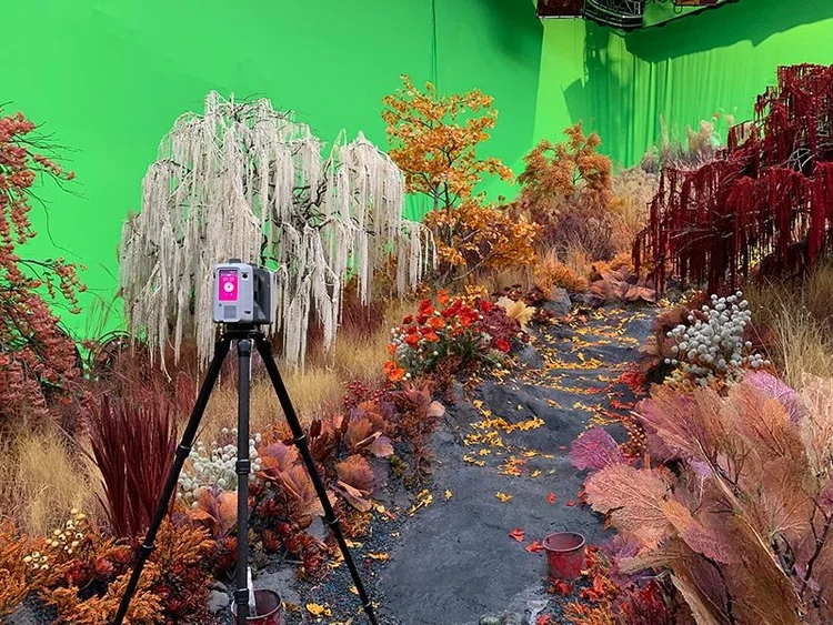
Sets are captured in the windows you have. Handheld SLAM covers a standing set or a dressed location in minutes rather than hours, and tripod scanning goes in where a hero prop or a wall detail needs tighter tolerance. Green screen, practical lighting and part-struck sets are all normal conditions; we work around the crew and mark what has moved between passes.
Continuity is the common reason for a second visit: a set scanned as built, then rescanned after a strike or a redress, gives editorial and VFX a measurable record of both states.
The difference between a useful scan and a nuisance one is convention. Before capture we agree: units and scale, up-axis, coordinate origin and its physical location on set, naming for objects and files, mesh density targets per asset class, UV expectations, texture resolution, and whether you want raw as well as processed data. We deliver a small test asset early on large jobs so your pipeline TD can confirm the convention before the full delivery lands.
We also agree what happens to the point cloud. Many facilities want it as the ground truth alongside the mesh, others only want the mesh; keeping both costs nothing extra at delivery and answers questions the mesh cannot.
Handheld SLAM LiDAR for whole sets, corridors, locations and anything needing speed: coverage in a walk, at ≤1 cm relative within 10 m. Tripod scanning for hero geometry: a facade bay, a wall of detail, a prop that will be seen close-up, at 4 mm @10 m per station. Photogrammetry for texture-critical surfaces and small props where colour and detail matter more than absolute geometry. 3DGS where the look of a place, including its light, is the deliverable.
Most jobs mix at least two. Deciding which per asset before the shoot day is what keeps capture inside the window you have.
Scans are cheapest when planned as part of the shooting schedule rather than requested after wrap. A practical pattern: capture the set as built before the first shoot day, capture again after any significant redress, and capture the location once more if practical elements are removed. Because each pass is registered to the same origin, the states can be compared directly, which is what makes them useful to editorial and VFX months later.
A scan records surfaces, not materials: it tells you where a wall is and what it looks like, not what it is made of or how it should be lit. Highly reflective, transparent and very dark surfaces capture poorly and may need reference photography instead. Actors and moving elements are not captured. And a scan is a record of a moment, if the set changes, the scan does not.
Priced by set count, capture window and deliverable density. Out-of-hours and between-unit windows, tight schedules requiring standby time, and heavy mesh and texture processing all move the figure. Typical turnaround: point cloud within days, processed meshes within one to two weeks, faster where a pipeline needs a quick proxy first.
Send the schedule and the pipeline you deliver into to get a quote.
Scan cost is driven by time on set, and time on set is driven by your schedule rather than by geometry. A few practical levers. Book the window, not the standby. A defined 45-minute slot between units costs a fraction of a day of standby, and handheld capture fits into that slot.
Decide the hero assets in advance. Tripod-grade capture on three surfaces the camera will see close-up is cheap; tripod-grade capture on everything is not. A short walk-through with your VFX supervisor before the shoot resolves this in minutes.
Ask for proxies early. Low-density geometry within days keeps layout and previs moving while final meshes and textures are processed, and it costs nothing extra because it comes from the same data.
Capture the location once more than feels necessary. The revisit nobody budgeted for is the one after a strike, when a set no longer exists and a shot needs extending. A second pass at the time is a fraction of the cost of rebuilding from photographs later.
Keep the point cloud. Facilities routinely ask for meshes only, then need a measurement six months on. Including the registered cloud at delivery costs nothing and answers those questions without a revisit.
Location capture has different constraints from set capture. Sets are controlled; locations are borrowed. So the practical questions are who grants access, for how long, and what may be published or retained afterwards.
Access windows. Public and operating locations, malls, transport, temples, heritage buildings, typically permit capture outside operating hours only, and handheld capture is what makes those short windows workable. A location that would take a tripod team a day is often a 60- to 90-minute walk-through.
Permissions. Confirm before capture whether the owner permits scanning at all, whether the data may be used in a commercial production, and whether the location may be identified. Heritage and religious sites frequently have specific conditions. Getting this in writing protects the shot later, when the asset is already in a sequence.
Discretion. Handheld capture is unobtrusive, needs no lighting or power, and leaves nothing behind, which is often the deciding factor in whether permission is granted at all.
Archiving. Location data outlives the production that paid for it. Agree at delivery where the master data lives, in what formats, and who holds it: the facility, the production company, or both. Registered point clouds and meshes in open formats remain readable in a decade; project files from a specific software version may not. We deliver both and label the masters clearly so the archive is usable by whoever inherits it.
Scan teams that get invited back are the ones that do not slow the day down. In practice that means: arriving with the capture plan agreed, working to the AD rather than around them, never asking for lighting changes, keeping cases out of walkways, and finishing inside the stated window rather than asking for five more minutes when a unit is waiting.
Where a shoot is live, handheld capture is the quiet option: no cabling, no tripods to trip over, no power draw. Tripod positions are scheduled explicitly as short holds rather than assumed. And when a set is being struck, we work with the construction team’s sequence: capture ahead of the strike on the elements that matter, rather than trying to stop it.
Nominate one contact, usually the VFX supervisor or the on-set data wrangler, and we report to them: what was captured, what was missed, what needs a second pass. A one-page capture log at the end of the day is worth more to editorial six months later than any amount of goodwill.
Units, up-axis, origin, naming, mesh density and formats agreed with your pipeline TD.
Capture windows planned around the shooting schedule, redresses and strikes.
Handheld SLAM for coverage, tripod for hero detail, photogrammetry for texture, 3DGS where the look is the deliverable.
Registration, cleanup, decimation and UVs to the agreed density; test asset issued first on large jobs.
Meshes, point clouds and scenes named and scaled to convention, with camera references tied to the same origin.
| Deliverable | Format | Typical destination |
|---|---|---|
| Decimated mesh with UVs | OBJ · FBX · USD · glTF | Maya, Houdini, Blender, Unreal, Nuke |
| Registered point cloud | E57 · LAS / LAZ | Ground truth for match-move and measurement |
| 3DGS scene | Splat scene + browser viewer | Previs, layout, virtual production plates |
| Textures | EXR · PNG · JPEG | At the resolution agreed per asset class |
| Camera and origin references | Documented positions | Match-move and multi-pass alignment |
| Proxy geometry | OBJ · FBX | Early low-density version so work can start before final delivery |
Naming, scale, up-axis and density are agreed before capture. On large jobs a test asset goes out first so your TD can confirm the convention.
OBJ, FBX, USD, glTF, E57 and LAS. We agree naming, scale, up-axis and mesh density before capture so the first delivery is the usable one.
A dressed standing set is usually 30 to 90 minutes with handheld SLAM. Tripod scanning for hero detail adds time per position, so we plan around your window rather than the other way round.
Yes, in most cases. Handheld capture needs a walkable path and no more than that. Tripod positions need brief clear frames, which we schedule with the AD.
Both, if you want both. The mesh is what most departments work in; the point cloud is the ground truth behind it and costs nothing extra to include.
Yes: photogrammetry for texture-critical small subjects, tripod scanning for hero geometry. Very reflective, transparent or very dark surfaces capture poorly and may need reference photography instead.
Yes. Proxy geometry can go out within days while final meshes and textures are processed, so layout and previs are not blocked.
We capture the locations and deliver 3DGS scenes and geometry for them. Volume content assembly and on-set playback stay with your virtual production team.
Both, where continuity matters. Each pass is registered to the same origin so the states can be compared directly months later.
Proxy geometry, often yes: a walkable low-density mesh within a day. Final meshes with UVs and textures take longer; tell us what the next department needs first and we sequence delivery around it.
LiDAR capture can be colourised, and texture-critical assets are captured photogrammetrically or with reference photography so the maps are photographic rather than projected approximations.
Yes. Origin, units and up-axis are agreed before capture and physically marked on set, so multiple passes and multiple assets land in the same space without manual alignment.
Singapore is the base and the primary service area. Regional shoots are considered case by case: send dates, locations and the deliverable list with the enquiry.